Village Of Stokeford In 1930 And 2010
Here is a model answer for this question. Need help with IELTS writing? Get your essays, letters and reports corrected by me.
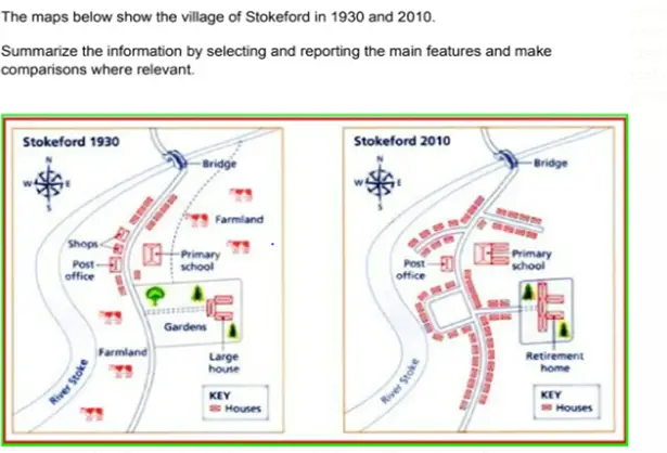
Sample report
The given maps show how the village of Stokeford looked in the years 1930 and 2010. Overall, it can be seen that the village underwent considerable changes over the period of 80 years. Actually, the only structures that did not undergo any change were the post office and the bridge on the river Stoke.
Stokeford is on the eastern side of the river Stoke and a road passes through its middle. In 1930, there was a primary school on the east side of the road and some houses to the north of the school. To the south of the school stood a large house and some gardens. On the north eastern side of the school was farmlands. On the western side of the road, there was a post office, some shops and a few houses to the north of the post office. The south-western part of the village used to be occupied by farmlands.
By 2030, the primary school had been expanded. The large house was replaced by a retirement home and in the place of the gardens, a few houses were built. The shops near the post office were demolished and new houses were built there. The farmland on the southern side of the village was also converted into a residential area with several new houses coming up there.