The Two Maps Below Show Road Access To A City Hospital In 2007 And 2010 | Task 1 Academic IELTS Report
The two maps below show road access to a city hospital in 2007 and 2010. Summarise the information by selecting and reporting the main features, and make comparisons where relevant.
Here is a band 8 IELTS report on this topic written by one of our students. Need help with IELTS writing? Get your IELTS essays, letters and reports corrected by me.
Band 8 IELTS report sample

The given two maps illustrate the road network around a City Hospital in 2007 and in 2010. Overall, it is noticeable that the road access to the city hospital had been upgraded in 2010 with the addition of a bus station, two roundabouts and a separate public car park.
In 2007, the hospital road, which had three bus stops on the either side, was connected to the city road and to the ring road. Furthermore, a common car park was located on the east side of the hospital road, and it served both public and staff members. In 2010, some significant changes could be seen. Firstly, the common car park was assigned exclusively for the hospital staff, while a novel public car park was established on the east side of the hospital. Secondly, two roundabouts had been constructed at both ends of the hospital road; one at the intersection with the ring road and other at the city road junction. Finally, the three bus stops on either side had been removed, and a new bus station was constructed on the west side of the hospital road with connections to the both newly built roundabouts.
Band 8.5 report sample
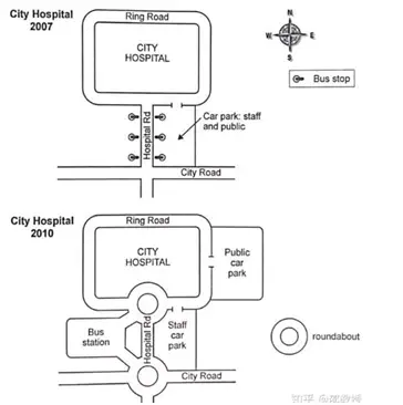
The two maps show the road network around a city hospital. In 2007, the hospital had a ring road around it. The hospital road connected the ring road to the city road and facilitated easy access to the hospital. There were staff and public car parking area on either side of the hospital road.
Massive changes took place over the next three years and by 2010, a public car parking area which opens to the ring road had been built on the east side of the hospital. A roundabout was built on both ends of the hospital road. A bus station was built on the west side of the hospital road and it can be accessed via the roundabouts. The car parking area on the east side of the hospital road was now reserved for the staff. While the bus station is connected to the city road via the roundabout, the parking areas can only be accessed through the ring roads.
Do you have a report on this topic? Submit it below in the comments for a free band score estimate.
How to improve your writing score
- How to avoid redundancy in writing
- Words and phrases you must not use in your essays
- Phrases you can omit from your IELTS essays
- Common linking expressions in English
- How to write concisely
- Linking words – on the other hand, while, whereas, however, in spite of
- Why you should not begin every sentence with a linking word
Both of the maps detail changes that had been made to the road accessing to a city hospital since 2007 to 2010. Overall, there was main developments in the main road in the center, relocation of parking spots and addition of a public facility.
It is apparent that in 2010, there had been a construction of roundabouts in both ends of the Hospital Road near the junction connecting to the Ring Road towards the north and to the City Road towards the south. The car park located in the east of the Hospital Road which was originally provided to staff and public had been solely used for staffs in 2010. Instead, the one for the public had been relocated to the northeast side.
In addition, there was only 6 row of bus stops in both east and west side of the Hospital Road in 2007; however, those stops have been removed and a new large bus station located west of the Hospital Road had been erected. There were 2 small roads connecting from the bus station to the roundabouts for easier access.
This seems band 6.5 to me.
The two rendered map illustrate how road was constructed to have access to the City Hospital in the year 2007 and 2010.
Overall, the major changes can be observed in the structure by year 2010. These changes includes; a new parking area, a specific bus station, and two new roundabouts was build, whereas, location of the roads (ring, hospital and city) and of the hospital remained same.
In the year 2007, only a single straight road (hospital road) from the south make way to the hospital in the north. This straight road passes through city road which was extended in the west and the east. Furthermore, six bus stops, the three to the left and three on the right side of the hospital road. However, the staff and public can make access to the parking area by just taking right turn from the hospital road or by coming straight downward from ring road along right side of the hospital,
By the year 2010, the whole structure was modernized. The old parking area reserved for the staff cars only, while new parking area in the east of the hospital was setup for the public sector cars. In the contrary, the one roundabout was form in the way between city hospital and other at the intersection made by hospital road on the city road. Both these roundabouts make way into the bus station in the west.
This seems band 6.5 to me.
The maps illustrate how to access to city hospital area in 2010 compared to three year ago.
All in all, it can be clearly seen that boundaries of the city hospital remained the same, while parking lots and bus waiting areas were extended. Besides that, new two roundabouts were constructed.
To begin with 2007, city hospital was located between the Ring Road and City Road, following by Hospital Road you could enter. On the Hospital Road, there were six bus stop, and the east side of the road car parking area which was open for staffs and citizens.
According to site plan of the hospital in 2010, there were two different parking lot that were staff car park is situated the south direction of the Hospital Road and the other car park for public was located the east side of the hospital. Bus stops were demolished and two roundabouts were added to Hospital Road. Lastly, new bus station area was created south side of the city hospital.
This seems band 6.5 to me.
The given two maps provide information about the comparison of the accessing road to a city hospital in the past and particular year in 2007 and 2010 respectively. Learning from an overall perspective, the major changes were ranging from parking separation, new bus station, and new roundabouts.
Firstly, It is evident that there was no difference in city hospitals between 2007 and 2010. It was largely the same and the building was unaltered. Secondly, the ring road and the city road underwent very little change, although there was addition of two lanes to link up to the new bus station.
On the other hand, there were significant changes in particular infrastructure in 2010. First and foremost, it is readily apparent in 2007 the parking area was mixed both for staff and society, but then in 2010 it was separated. Second, the bus stops were removed and renovated with a new bus station, which could be accessed throughout the new roundabouts that had been built.
This seems band 6 to me.
The two maps illustrate the throughway connection to a city hospital in the year 2007 and 2010.
Overall, it can be seen that the routes to a urban health service in 2010 had been modified with roundabout and bus station.
As it can be seen in 2007 map .the car parking for staff as well as public was combined and it had only one entrance to this parking area. Moreover, the parking was constructed at the east side of a city hospital. In addition to that there was six bus station which was divided into three bus stops each to the both sides of a hospital road .
Moving to 2010 map, the parking for health workers and visitors had been divided into two various block and it also had different access. Additionally, there was two roundabout constituted, one at the city road and other one to the ring way. It was noticed that bus station had another block which was opposite to the healthcare giver parking slots.
This seems band 6.5 to me.
The given data illustrates two maps which depicts the route access to a city hospital in the year 2007 and 2010.
Overall, it has been observed that few changes which has been done between the period of 3 year from 2007 to 2010 where roundabout is constructed on the city and ring road.
Initially, in 2007 the parking area was common for staff and public both but in 2010 plan the public car parking is shifted towards north-east corner whereas staff car parking area is at same location on south-east corner.
Additionally, the bus station location is allocated on the south-west corner on the right hand side of hospital road furthermore the entries into the bus station is given from both city and hospital road due to which the entrance for staff parking and public car parking is separated in the ring road due to which their will less traffic and easily accessible .
This seems band 6 to me. Grammar needs a lot of improvement.
The maps illustrate the path that leads to the city hospital .A comparison has been made by showcasing the advancements made between the period of 2007 and 2010.
Overall a lot of things has been changed as a shared path Park was switched for staff use only and a separate public parking area was allocated for public use. Also two roundabouts linking the city road to the hospital road and hospital road to the ring road could be seen.
In 2007 ,the ringg road that surrounds city hospital leads to the hospital road towards the south the hospital road had bus stop side to side. Shadred car parking for public and staff use was on the south east of the road.
In 2010, a public car park was built on the north-east of the city hospital moving towards a hospital road near bus station that had been connected by to roundabouts was on the south west of the city hospital. On the other side of the hospital road there was a staff car park at the roundabout make it easy to assess every point either it is a bus station car parking area or city hospital.
This seems band 6.5 to me.
The given two maps depicts the road access to the city hospital in 2007 and 2010.
In the first map, it shows in the year 2007 the main way to reach hospital is through the city road which is in the south of the junction. From the city road junction when we head towards the North to the Hospital road, we experience a car park space for staff and public on either sides of the road. As we keep going in the North direction we find a huge ring road which leads to the hospital, Besides this, there is a bus stop on the south east side, little away from the hospital.
Whilst there had been many changes in the year 2010. The start is same from the city junction but it is a circular way, when we head towards the North direction, we see only staff car park area on the right hand side, while the rectangular bus station additional on the left. As we move on, the hospital junction is also changed to circular junction to pass by easily and as we exit the junction we reach ring road which is the way to the hospital. Additionally, the car park space for public has allotted on the East side of the city hospital and the old bus stop on the south east has been changed into a round-about for other ways.
All in all the road access to city hospital has quite many changes, though, it look easy accessible for public transport commuters, and car park space for staff and visitors in the city hospital.
This seems band 6.5 to me.
The two maps illustrate the main changes which have taken place in road access to a city hospital between 2007 and 2010.
Overall, it can be seen that the road access has become more modern, with two roundabouts and a bus station.
In 2007, the hospital staff and the public used the same parking area which was to the east of the hospital road. A new car park for the public was placed to the east of the city hospital and the common parking area was reserved for the hospital staff in 2010. In addition, the three bus stops were located either sides of the hospital road in 2007 and they were demolished in 2010 to construct a new bus station to the west of the hospital road.
Furthermore, the two roundabouts were constructed in 2010, one at the city road junction and the other one at the ring road junction. Both roundabouts had been connected to the newly constructed bus stand which have led to reduce the traffic jam.
This seems band 7 to me.
The map showcases the access of roads to the city hospital in the year 2007 and 2010. It is clearly visible that there has been development since the year 2007 in terms of car parking, bus stop, and introduction of roundabouts.
As we can see, in the year 2007, the hospital had three bus stops on each side of the hospital road, from where the city road connected the ring road, along with one common parking lot for both public and staff which was on the east side of the hospital.
But, by the year 2010, there were major developments which transformed the hospital. There was construction of two car parking both on the east side, one for public which was on the east side of the ring road and the other one for the hospital staff members which was on the east side of the hospital road. Furthermore, there were two roundabouts which connected the hospital road to city road and ring road, respectively. Apart from this, the three bus stops were removed and there was a big bus station built to the west of the hospital road.
To sum up, the new built roundabouts, bus station and car parking space made the hospital easily accessible and spacious.
This seems band 6.5 to me.
The given two maps illustrate some informations of
one of the main road acces with a city hospital from 2007 to 2010. Overview, it seems that there are several changes by 2010 and the most importances are built new constructions, such as bus station and 3 roundabouts.
In general, it can be seen that in 2007 , city road had a special car park which is used by public and hospital workers.While ,public car park replaced to east side of hospital to 2010. Moreover, Car park of staffs served its place. Another changes, in a past western of Street was empty area, but after the 2010 it’s using by local people to bus station. In addition, the next most noticeable change was appeared roundabouts in street and south of the place.
This seems band 6.5 to me.
The given maps show the changes had done with road near the City Hospital in between the year of 2007 and 2010.
Looking for an overall view,The area besides the City Hospital has developed nicely within the three years.
First of all, The bus stop which was located both side of Hospital road has been upgraded to a proper Bus station at the left side of Hospital road and the right side is used as the staff car park which was combined with public park in the year of 2007. The public car park got a new space at the right side of Hospital’s ring road. Apart from that, The Hospital road is now connected with two new roundabout which connects the ring road, bus station and city road.
At the end, It is clearly seen that the city hospital had emple space of parking for public and staff and the circles for the solution of traffic.
This seems band 6 to me. Grammar needs a lot of improvement.
The given maps show the road access to a city hospital and changes occurred in 2007 and in 2010.
We can see that the bus station is added in 2010 while the staff and public car staff parking built separately in 1010.
In 2007, the city road is on the east side and ring road is on the back side of city hospital or we can say its present on the north side of the city hospital. To get to the city hospital road from city road towards south and then move towards north then you wl get to city hospital road. There is a car parking for public and staff towards east side of the hospital road and also have the bus station on side of the road.
On the other hand, in 2010 there are few changes made like towards city road to south side there is a roundabout then the parking slot for staff is east side of the city hospital road and on the other side of the road there is a bus station built separately. Towards the north side of the hospital road there is again a roundabout and on the top of the city hospital there Is a ring road.
The major difference between these two years is that in 2010 parking system is bult separate for public and staff and also the addition of roundabouts
This seems band 6.5 to me. Grammar needs to be improved.
The diagrams below illustrate the changes in the layout of a city hospital between 2007 and 2010. Overall, it can be generalised that although the rough structure of the roads remained the same, a couple of new car parks and stations were developed over the three-year period.
After 2007, two roundabouts were built on the junction between Hospital Road and Ring Road, as well as the intersection between City Road and the aforementioned Hospital Road. The six bus stops that ran alongside Hospital Road were demolished, and replaced by a bus station which had been developed on the western side of Hospital Road. Two new lanes were also made to connect it to Hospital Road, to allow the movement of buses to and from the station.
On the opposite side of Hospital Road, a staff car park was erected, which was able to be accessed from the southern part of Ring Road. Additionally, a public car park was built on the same road, a stone’s throw away from the staff car park.
This seems band 7 to me.
The following maps display how the road access to a city hospital has changed between the years 2007 and 2010.
At first glance, we can see that the road network has been modernized with the addition of a bus station and roundabouts. Furthermore, a separate car park for public vehicles has also been added.
In 2007, the hospital road had three bus stops on each side and was connected to the city road and the ring road. A joint car park was located on the east side of the hospital road. Firstly, in 2010, the common car park was made exclusive to staff members and a second car park was constructed to the east of the hospital for public access. Secondly,to the west of the hospital road, a bus station was constructed which replaced the old bus stops. Moreover, two roundabouts; each connected to the bus stops, were added to each end of the hospital roads.
This seems band 7 to me.
The two maps illustrate the ways in which the changes that the road access to a city hospital had undergone by 2010 compared with 2007.
Overall, it is conspicuous that the city hospital had witnessed some changes, with contracting two roundabouts, expanding more spaces for a staff-only car park, and replacing six bus stops with a bus station over the following three years.
To start with, in 2017, surrounding the hospital was a Ring Road, which was connected to the City Road by the Hospital Road, and there was no roundabout, but the first roundabout is at the intersection of City Road and Hospital Road, while the second is at the other end of Hospital Road, at the junction with the hospital ring road in 2010.
By 2010, the bus stops on two sides of the hospital road were replaced by a large bus station, which had direct access to the two roundabouts.
There was a staff and public car park on the southeast of the ring road in 2017, but it has been converted to only for hospital staff, and a new common car park was built on the east of the ring road over the following three years.
This seems band 6.5 to me.
Two maps illustrate city road has an access to a hospital in the city in 2 years, 2007 and 2010.
It was a city road that had a connection to the city hospital with only a road, Hospital road. There was a car park for customers and staff on the left of this street. People could drive around this mega place on the Ring road. The bus stop could be seen in the easternmost part of the map.
However, after three years, the bus station existed in the south of the central place for sick people with two branches which were connected by two new squares. Staff and people did not have the same car park. The public car park was separated and constructed in the east of the significant place. A Roundabout was seen in the previous place of the bus stop.
I would like to introduce some of the places which are not relocated. Hospital is the first one, staff car park and hospital road were second and third, respectively. City road was still in the same area.
This seems band 6 to me. Grammar needs improvement.
The two maps show the difference in road access to a city hospital from 2007 to 2010.
On the first map, we can see that there are six bus stops scattered throughout Hospital Road, with a car park for staff and public vehicles on the east side. On the north side of the car park stands an entrance to the city hospital, and on the south side is a city road.
As of 2010, all bus stops have been removed and a bus station has been rebuilt to the west of Hospital Road and to the east, with the car park remaining, but only allowing staff cars to park there. All public cars may park at the new public car park on the east side of the ring road. There are two more roundabouts on Hospital Road, one linking to City Hospital and the other to City Road.
All in all, the public transport system around the hospital has become increasingly convenient.
This seems band 6.5 to me. Write at least 150 words
The map illustrates how the city hospital expected the reconstruction in accessibilities over the three years.
Overall, comparing the two maps, it is clear that the area had witnessed big changes in accessibility. Not only lots of facilities were made for private transportation like expanding parking but also for public transportation the bus station complex was built.
In the center of the site, two roundabouts were erected which were a cross of a ring road, hospital road, and city road. In 2007 the car park had been located in the east of the hospital site and after redevelopment car parking was separated into two types. One of them became a staff car park which remains in the past location and another one was named a public car park which was situated on the extra site close to the east of the city hospital.
According to a proposal in the past bus stations were on the side of the hospital road but then bus station space was introduced and all of them were moved there. At least but not least the city hospital and ring road had been through no significant change and remain stable.
This seems band 6.5 to me.
The two illustrations below provide information about changes in the hospital area and road access.
On the first map in 2007, it is noticeable that there was one road to the city hospital. Moreover, there was a public transport system which connect to it, at peak time people who came by car can stuck. In addition, it could close a road for an emergency.
In the second illustration, as it can be clearly seen, stops have been removed and a new large bus station on Hospital Rd. Also added additional ways to it. Parking for visitors was replaced to the east side of the hospital, to avoid collisions on shared as it could be in 2007. Furthermore, to reduce road traffic was made a roundabout for faster and easier movement
Summing up, the area was renovated extensively seen fundamental changes seen improvements in road junctions. From upgrading, hospitals become more accessible for all residents.
This seems band 6 to me. You don’t have to make assumptions like people will get stuck in traffic. Just report what is given in the map.