Stokeford In 1930 And 2010
Summarise the information by selecting and reporting the main features, and make comparisons where relevant.
Sample report
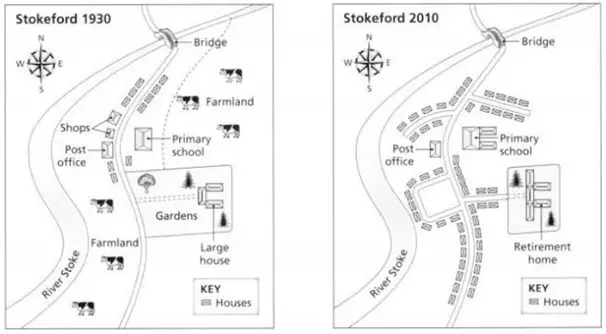
The first map illustrates how Stokeford looked in 1930, while the second map shows its appearance in 2010. The city has undergone major changes and much of the farmland has been replaced by houses. The city is located on the eastern bank of river stoke. The bridge connecting the city to the western bank of the river is still there. In 1930, the city had a single road connecting the southern end of the city to the bridge and a few houses were situated adjacent to the road on the northern side, whereas in 2010, new branching roads were laid to provide connectivity to the new housing. The post office which was present on the western side of road was not modified. Also the primary school was extended with two other new blocks and shops adjacent to the post office were removed for laying a new road. Farmlands lying in the southern and north-eastern ends occupied a major portion of the village in 1930, while in 2010 they were replaced by houses. The garden’s area is reduced to half over the time to accomodate more houses and a large house in the garden was modified to a retirement house.